Description (050.02.07.01)
Describe jet streams (050.02.07.01.01).
State the defined minimum speed of a jet stream (60 kt) (050.02.07.01.02).
State the typical figures for the dimensions of jet streams (050.02.07.01.03).
Jet streams are strong narrow currents of air on a nearly horizontal axis in the upper troposphere or low stratosphere, characterized by strong lateral and vertical wind shears.
In order to classify as a jet stream the wind speed must be at least 60 KT.
The polar front jet stream reaches speeds of around 200kt, the weaker sub-tropical jet peaks at around 100kt.
Jet streams are typically thousands of kilometers long, 2NM (12.000 ft) deep and 200NM wide (1:100).
Formation and properties of jet streams (050.02.07.02)
Explain the formation and state the heights, the speeds, the seasonal variations of speeds, the geographical positions, the seasonal occurrence and the seasonal movements of the arctic (front) jet stream, the polar (front) jet stream, the subtropical jet stream, and the tropical (easterly/equatorial) jet stream (050.02.07.02.01).
Jet streams form where the pressure gradient between two air masses is the greatest. These pressure differences at height are caused by marked temperature gradients at the boundaries of air masses.
The marked temperature gradients are at the boundaries between the arctic and polar air, polar and sub-tropical air and the more diffuse boundary between the sub-tropical and tropic air at the equator. We therefore recognize:
- Polar-night jet stream (westerly);
- Arctic jet stream (westerly);
- Polar front jet stream (westerly);
- Sub-tropical jet stream (westerly);
- Equatorial jet stream (easterly);
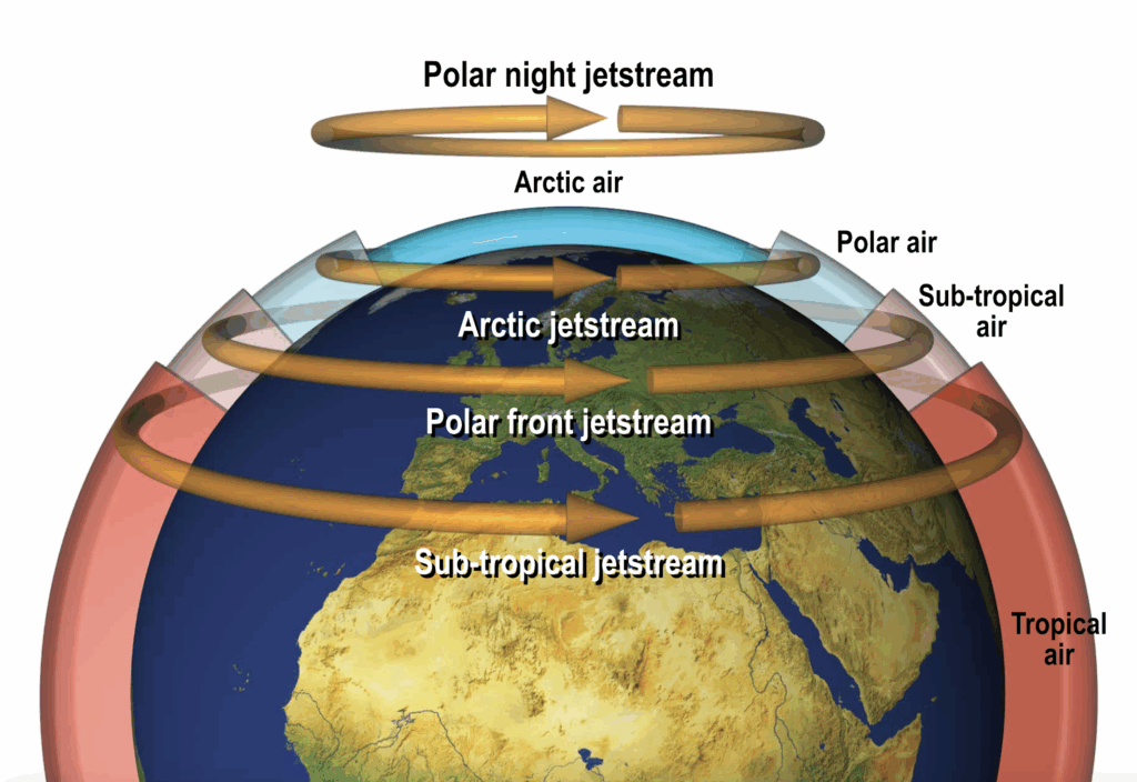
Polar-night and Arctic Jet Streams
In winter, the long polar nights cools the polar air forming a distinct arctic air mass between about 70° latitude and the poles.
The temperature difference between the polar air and the arctic air is now sufficient enough to cause an arctic jet stream to develop. The core is found at about 20,000 ft and the maximum wind speeds are around 80 kt.
Polar and Sub-tropical Jet Streams
The polar and sub-tropical jet streams are associated with the polar front and the sub-tropical front. The polar and sub-tropical jet streams move with these fronts, being closer to the Equator in winter. Both jet streams are usually characterized by stronger wind speeds in winter.
Polar and Sub-tropical jet streams are closer to the Equator in winter.
Polar and Sub-tropical jet streams are faster in winter.
The polar front jet stream is typically found at around 30,000 ft (300 hPa), the sub-tropical jet stream is higher in the warmer tropical air, around 40,000 ft.
The polar front jet stream reaches speeds of around 200 kt, the weaker sub-tropical jet peaks around 100 kt.
Equatorial Jet Stream
The equatorial jet stream is the only easterly jet stream. It is caused by summer heating of the Indian sub-continent and coastal regions of West Africa.
The surface heating is so intense, that it is transfers into the upper air where a marked temperature difference develops between the upper air over the land and that over the sea. Uncommon for the northern hemisphere, the hot air is to the north of the cooler air, causing easterly winds at height.
This can just reach jet speeds (60kt) over West Africa and more severe at over 100kt over India. The core of the equatorial jet stream lies at about 45,000 – 50,000 ft.
Location of jet streams and associated CAT areas (050.02.07.03)
Sketch or describe where polar front and arctic jet streams are found in the troposphere in relation to the tropopause and to fronts (050.02.07.03.01).
Describe and indicate the areas of worst wind shear and CAT (050.02.07.03.02).