General aspects (050.06.02.01)
Describe the boundaries between air masses (fronts) (050.06.02.01.01).
Define ‘front’ and ‘frontal zone’ (050.06.02.01.02).
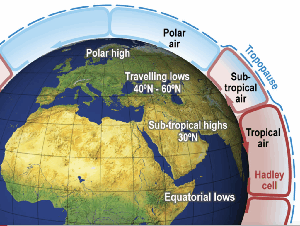
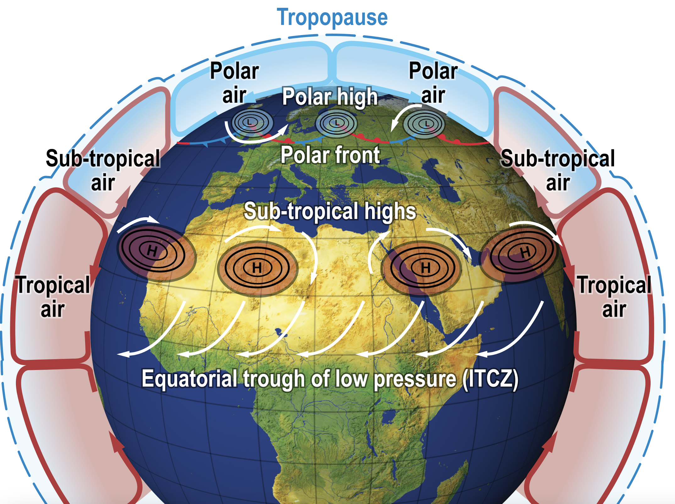
The vertical circulation takes place on a global scale tied into three main bands: tropical, sub-tropical and polar air. The transition zone between two air masses is called the frontal layer and where this meets the surface of the Earth it is called a front.
Name the global frontal systems (polar front, arctic front) (050.06.02.01.03).
State the approximate seasonal latitudes and geographic positions of the polar front and the arctic front (050.06.02.01.04).
The sharp boundary at which the polar air is separated from the sub-tropical air is called the polar front.
The North Atlantic polar front lies in winter along a mean line from Florida to Brittany (mid France), and in summer from Nova Scotia to the Scottish Islands.
Warm front, associated clouds and weather (050.06.02.02)
Define a ‘warm front’ (050.06.02.02.01).
Describe the cloud, weather, ground visibility and aviation hazards at a warm front depending on the stability of the warm air (050.06.02.02.02).
An observer on the ground watching the approach of a warm front will start off in the Polar air (usually mPc). The polar air generally arrives at North-West Europe from the N and NW as cool, moist and unstable air. Therefore the weather ahead of the warm front consists of convective clouds (Cumulus (Cu) and Cumulonimbus (Cb)), showers and good visibility (except in clouds).
At a warm front, warm air is moving towards cold air. The warm air is lighter than the denser cold air and as the warm front approaches, the warm air slides over the cold sector and creates a temperature inversion at height. The temperature inversion stabilizes the polar air, and the convective activity begins to die out.
The maritime Tropical warm (mTw) is very stable all the way up to the tropopauze and the warm air that slides up the front is cooling and creating stratiform cloud. At first high Cirrus (Ci) and Cirrostratus (Cs) clouds, but as the front approaches, the clouds come lower and lower, giving way for Altostratus (As) and eventually Nimbostratus (Ns) which produces precipitation. At first as drizzle and changing to continues rain.
Explain the seasonal differences in the weather at warm fronts (050.06.02.02.03).
In winter, traces of light rime icing can occur in Altostratus, mixed icing can occur in the Nimbostratus. But by far the worst hazard at the warm front in winter is rain ice.
Describe the structure, slope and dimensions of a warm front (050.06.02.02.04).
The frontal layer of a warm front lies at an angle forwards and above the cold air. The average gradient / slope is about 1:150. Due to this gradual slope the cloud mass can be seen on an average of 750 NM ahead of the warm front. The average width of the precipitation zone is about 185 NM (300 km).
The frontal layer itself is about 30 to 60 NM wide.
Warm fronts generally move at an average speed of 10 knots, which is 2/3 of the speed of a cold front.
Sketch a cross section of a warm front showing weather, cloud and aviation hazards (050.06.02.02.05).
Cold front, associated clouds and weather (050.06.02.03)
Define a ‘cold front’ (050.06.02.03.01).
Describe the cloud, weather, ground visibility and aviation hazards at a cold front depending on the stability of the cold air(050.06.02.03.02).
At the cold front, cold polar air (usually mPc) is moving towards the warmer sub-tropical air. The cold air undercuts and lifts the warm air, pushing it upwards.
Explain the seasonal differences in the weather at cold fronts (050.06.02.03.03).
Describe the structure, slope and dimensions of a cold front (050.06.02.03.04).
The frontal layer of a cold front lies at an angle backwards and under the warm air. The average gradient / slope is about 1:80. Due to this steep slope the cloud mass is only about 120 NM ahead wide. The average width of the precipitation zone is about 60 NM (300 km). The frontal layer itself is again about 30 to 60 NM wide.
Active cold fronts generally move at an average speed of 15 knots.
Sketch a cross section of a cold front showing weather, cloud and aviation hazards (050.06.02.03.05).
Stationary front, associated clouds and weather (050.06.02.07)
Movement of fronts and pressure systems, life cycle (050.06.02.08)
Describe the movements of fronts and pressure systems and the life cycle of a mid-latitude depression (050.06.02.08.01).
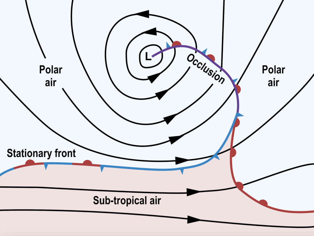
At the polar front, air leaving the polar heigh (usually the mPc) and the air mass leaving the sub-tropical high (usually the mTw) meet and sets up a pattern of air running in opposite directions.
The front surface slopes, so that the less dense warm sub-tropical air overlies the cold polar air partially.
Without movement, the front is known as a stationary front. Shown on surface charts combining the symbols of the warm and cold fronts.
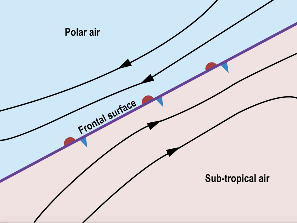
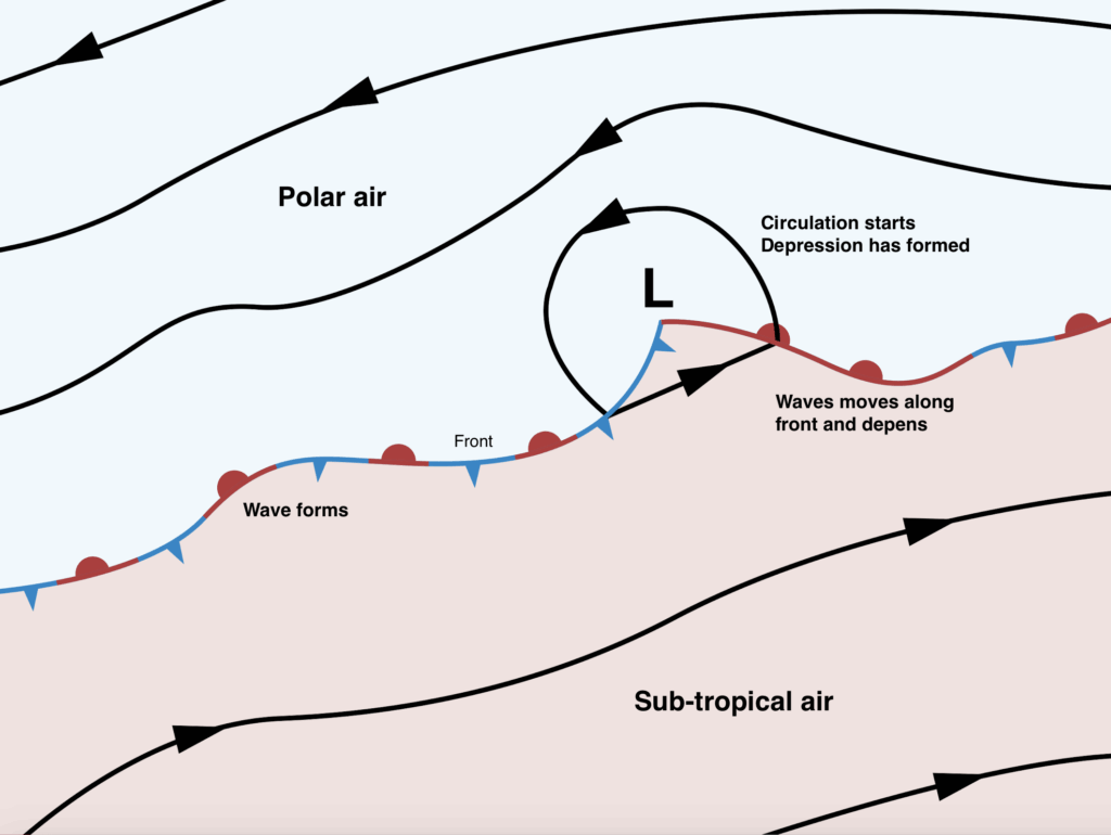
A stationary front is an unstable situation and more often the front wobbles and forms waves.
If the length of the waves is between ± 500 km and ± 1600 km along the front, the waves will deepen.
Because of the intruding less dense warm air in the wave replaces the cold dense air, the surface pressure is reduced and a depression forms.
Convergence toward the low will be deflected by the Coriolis effect, circulation will begin, and the characteristic isobar pattern of a frontal depression will appear.
The wave and the depression will move along the front line at about the 2000 ft wind (free stream). Because the sub-tropical air overlies the polar air at 2000 ft, the wave and the depression will follow the sub-tropical southwesterly wind (so the depression moves north east along the front line).
The isobars in the warm sector tend to be straight and parallel and give a good indication of travel of the system until it occludes.
As the energy of warm air (heat or latent energy due to condensation) is carried upwards, it changes into kinetic energy and increases the circulating wind speed. This lowers the pressure at the centre even further and keeps on stimulating the convergence at the surface. The depression has become self-sustaining.
While this is going on, the circulation is pulling cold air down to the warm side, forming a cold front (mPc). The cold front is moving faster than the warm front, so the cold front will gradually catch up with the warm front.
When the cold front overtakes the warm front, an occluded front (occlusion) is formed. The cold air squeezes the warm air sector up, cuts off the warm air feed, and the end of the depression is near.
| Position | Surface W/V | Temperature | Pressure | Cloud | Precipitation | Visibility |
|---|---|---|---|---|---|---|
| Ahead of the warm front | Speed increasing, slightly backing, usually S, SW | Steady low / cold | Steady decrease | Increasing to overcast, base lowering from Cirrus (Ci), Cirrostratus (Cs), Altostratus (As) to Nimbostratus (Ns) | Continues light rain from Altostratus (As) and then moderate to heavy continuous from Nimbostratus (Ns) | Gradually reducing to poor as the front approaches. |
| At the warm front | Veers sharply, windspeed decreases slightly | Sudden rise | Stops falling (lowest value) | Overcast layer of Nimbostratus (Ns) and Stratus (St), base very low | Moderate or heavy continuous rain/snow from NS | Very poor, fog can occur. |
| In the warm sector | Steady, usually from the SW. | Steady warm | Steady low | Broken to overcast, some large breaks may occur. Base low of Stratus (St) and Stratocumulus (Sc). | Light rain, drizzle | Poor |
| At the cold front | Veers sharply (strong gusts and squalls likely) | Sudden decrease | Falls briefly | Broken to overcast, with Cumulus (Cu) and Cumulonimbus (Cb). Base low but rising, possible Nimbostratus (Ns). | Heavy rain or snow showers, thunderstorms and hail possible. | Good, except in precipitation |
| Behind the cold front | Steady, NW | Steady, Cool | Increases slowly | Broken to overcast, base lifting, occasional Cu, Cb | Occasional showers from Cumulus (Cu) and Cumulonimbus (Cb) | Very good, except in showers |
State the rules for predicting the direction and the speed of movement of fronts (050.06.02.08.02).
State the difference in the speed of movement between cold and warm fronts (050.06.02.08.03).
State the rules for predicting the direction and the speed of movement of frontal depressions (050.06.02.08.04).
Describe, with a sketch if required, the genesis, development and life cycle of a frontal depression with associated cloud and rain belts (050.06.02.08.05).