Altitude is more than just a number on your altimeter — it’s fundamental to safe and efficient flight. Pilots must interpret altitude correctly from the height above sea level to the aircraft’s position relative to atmospheric pressure to ensure terrain clearance, airspace separation, and aircraft performance.
Terminology and definitions (050.01.06.01)
Define the following terms and explain how they are related to each other: height, altitude, pressure altitude, FL, pressure level, true altitude, true height, elevation, QNH, QFE, and standard altimeter setting (050.01.06.01.01)
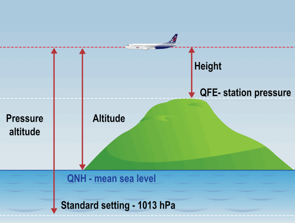
Altitude is defined as the vertical distance above Mean Sea Level (MSL).
Elevation is defined as the vertical distance of a ground point above Mean Sea Level.
Height is defined as the vertical distance above a ground point or level, therefore equals Altitude minus Elevation.
Aircraft are equipped with a device called an altimeter, which indicates the vertical distance of the airplane with respect to a specific datum. The datum it refers to, is depending on the barometric setting applied to the altimeter:
(Q)FE: barometric pressure measured at a ground point or level. If the QFE is set on an altimeter it should read zero on the ground at the airfield.
(FE refers to Field Elevation)
(Q)NH: is the barometric pressure at the station (QFE) adjusted down to mean sea level (MSL), using the International Standard Atmosphere (ISA) values for the temperature between the station and MSL. If the QNH is set on an altimeter, it should read the field elevation when on the ground at the station.
(NH refers to Nautical Height).
(Q)FF: is the barometric pressure at the station (QFE) adjusted down to mean sea level, using the actual atmospheric conditions.
Station above sea level, warmer than ISA, then QNH > QFF
Standard pressure: above a set altitude, called the transition altitude, aircraft operate with a ISA standard pressure of 1013.25 hPa (29.92 inHg) at mean sea level. So, when climbing through the transition altitude, the pilot has to change the barometric setting of the altimeter from QNH to the standard pressure of 1013 hPa.
The vertical distance of the airplane to MSL, when the standard pressure is selected on the altimeter is called pressure altitude, and is given as Flight Level (FL) – knocking off the last two (2) zeros. (i.e. pressure altitude 4000 ft equates to FL040).
Describe the terms ‘transition altitude’, ‘transition level’, ‘transition layer’, ‘terrain clearance’, ‘lowest usable flight level’ (050.01.06.01.02).
Transition altitude is the vertical distance above MSL at which aircraft switch from using local atmospheric pressure (QNH), to using standard pressure (1013.25 hPa). Below the transition altitude, height is reported as an altitude (e.g. 5000 ft). Above the transition altitude, height is reported as a flight level (e.g. FL070).
If the pressure drops below 1013.25 hPa, the lowest FL will increase in numerical value for a given transition altitude.
Transition level is the vertical distance above MSL at which aircraft switch back from using standard pressure to using local atmospheric pressure (QNH).
Transition layer is the airspace between the transition altitude and the transition level. Aircraft climbing pass through this layer when switching from altitude to flight level, and descending aircraft do the reverse.
Terrain Clearance or Minimum Safe Altitude (MSA) defines the minimum vertical distance to maintain in order to avoid obstacles or high terrain. Barometric and temperature corrections have to be applied to ensure that no infringements if the MSA occur.
Altimeter settings (050.01.06.02)
Name the altimeter settings associated to height, altitude, pressure altitude and FL. (050.01.06.02.01)
For height, vertical distance to the ground station, use QFE (field elevation).
For altitude, vertical distance to MSL, use QNH.
For pressure altitude and FL, vertical distance to MSL based on the standard ISA pressure, use 1013.25hPa.
Describe the altimeter-setting procedures (050.01.06.02.02).
Calculations (050.01.06.03)
Calculate the different readings on the altimeter when the pilot uses different settings (QNH, 1013.25, QFE) (050.01.06.03.01).
Illustrate with a numbered example the changes of altimeter setting and the associated changes in reading when the pilot climbs through the transition altitude or descends through the transition level (050.01.06.03.02).
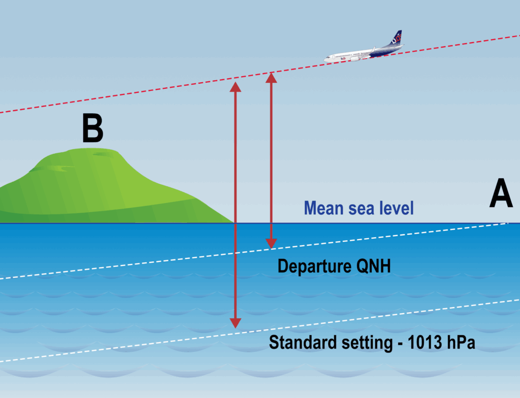
Changing the sub-scale settings.
When the pilot changes the altimeter sub-scale setting, the reading of the altimeter changes because the altitude is being referenced to a different datum.
In order to solve questions involving calculations concerning sub-scale setting changes, draw a diagram. Make sure the highest pressure datum is at the bottom and the lower pressure datum is on top.
Derive the reading of the altimeter of an aircraft on the ground when the pilot uses the different settings (050.01.06.03.03).
Explain the influence of the air temperature on the distance between the ground and the level read on the altimeter and between two FLs (050.01.06.03.04).
Noteworthy exam question:
During descent, the transition level given by ATC is at FL55; true altitude is 6 000 ft; local QNH is unknown. What assumption (if any) can be made about the airmass in which the aircraft is flying?
(a) it’s warmer than ISA
(b) there is insufficient information to make any assumptions
(c) it’s average temperature is the same as ISA
(d) it’s colder than ISA.
You might want to go for the answer “higher than ISA”, as the true altitude is higher than the pressure altitude.
However, the QNH is unknown, so we could not derive the indicated altitude from the pressure altitude. It could have been a high QNH that resulted in a higher pressure altitude than the FL.
We don’t have sufficient information, answer b
Explain the influence of pressure areas on true altitude (050.01.06.03.05).
Determine the true altitude/height for a given altitude/height and a given ISA temperature deviation (050.01.06.03.06).
Calculate the terrain clearance and the lowest usable FL for given atmospheric temperature and pressure conditions (050.01.06.03.07).
State that the 4 per cent-rule can be used to calculate true altitude from indicated altitude, and also indicated altitude from true altitude (not precise but sufficient due to the approximation of the 4 per cent-rule.) (050.01.06.03.08).
Barometric Errors
Surface pressures change, and if an incorrect pressure setting is left on the altimeter it will indicate higher than it should (over read), or indicate lower than is should (under read). This is called barometric error.
Barometric errors are particularly dangerous if you fly from high pressure to low, for the altimeter to over read.
From high to low, careful go.
For calculations from pressure altitude to indicated altitude and vice versa, use: 30 ft / hPa.
Temperature Errors
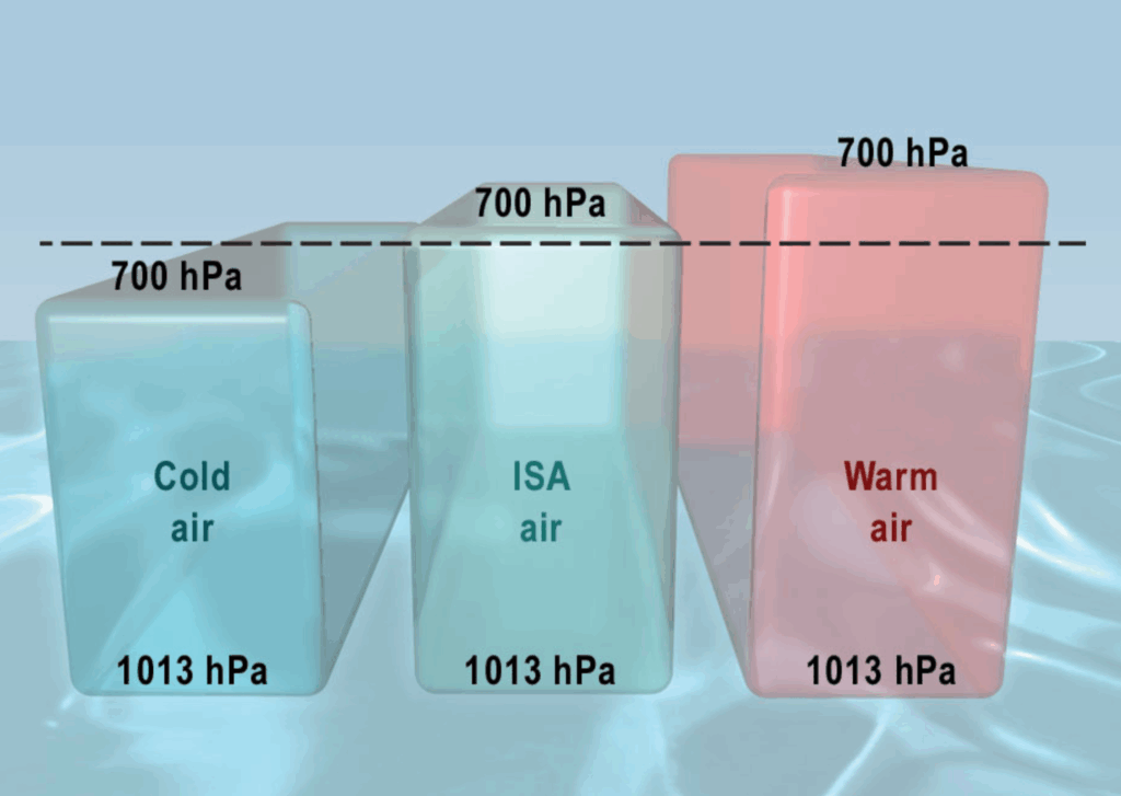
Not only surface pressure changes over time, temperature does too. True altitude will differ when the temperature deviates from the ISA values.
In high temperature air masses, any given pressure level will be at a greater altitude than in cold air masses.
In ISA temperature conditions: 700 hPa-level is at ± 10 000 ft;
In cold air conditions: 700 hPa-level is lower than 10 000 ft;
In warm air conditions: 700 hPa-level is higher than 10 000ft.
As the altimeter in all cases reads 10 000 ft, we can state that an altimeter over reads in cold air conditions, and under reads in warm temperature conditions.
To calculate the temperature error correction:
(1) Calculate barometric error to get Indicated Altitude;
(2) Calculate temperature error, using:
4 x (indicated altitude / 1000 – altitude of station of measurement / 1000) x ISA deviation.
(3) Derive the True Altitude.
Add the temperature correction (positive) to, or subtract the temperature correction (negative) from to the Indicated Altitude to derive the True Altitude.
From True to Indicated , changes the signs!!!!